The impact of COVID-19 lockdowns on wildfires in the United States
Did the lockdown increase the prevalence of wildfires?
This paper was an extremely interesting and unexpected read. This study claims that a reduction in particulate matter from the COVID-19 pandemic may have contributed to an increase in wildfires across the Western United States.
Naturally, we would assume that a reduction in air pollution and greenhouse gas emissions would always be a positive occurrence. However, this paper implies that a lockdown-induced reduction may have resulted in an increase in wildfires across the Western United States.
This study isn’t exactly focused on earth observation data, but it’s extremely interesting and future applications for EO data in this type of work are clear.
Link to paper: https://doi.org/10.1029/2022GL099308
Introduction
I really enjoyed this paper because it read like a textbook as much as it did a research study. We really get to understand the influence aerosols have on atmospheric phenomena such as precipitation, temperature and fire aridity (think dryness).
Research Goal
Explore the impact of COVID-19 on wildfire spread across the Western United States
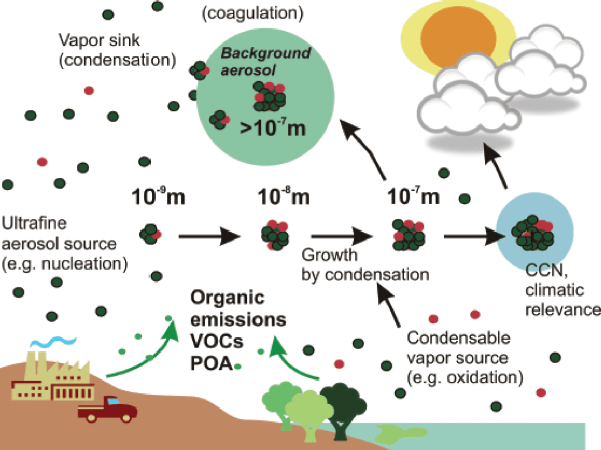
In the following image, you can see the impact that aerosols can have on atmospheric processes. They can serve as a source of condensation for clouds and impact the efficiency of precipitation (Ren et al., 2022). Some more interesting facts about the impact of aerosols on climate:
past aerosol-climate models indicate that a reduction in aerosols may increase the warming effect and risk of extreme temperature
A study focused on China stated that the COVID-19 lockdowns inducted a warming effect between 0.05 and 0.15 Kelvin
In Canada, the risk of extreme fire has increased six-fold due to anthropogenic climate change
How did they study the impact of COVID-19 on wildfire spread?
First, they quantified the reductions in aerosols and greenhouse gases.
This was done by running three climate simulations using a global climate model called the Community Earth Systems Model (CESM). The three differences between the models were as follows:
No reductions in emissions (i.e. no COVID-19 lockdowns)
Reduction in aerosols only (no reduction in GHGs)
Reduction in aerosols AND greenhouse gases (methane, nitrous oxide and carbon dioxide) gases
The simulations were run beginning in January 2020. Then, they compared the differences in emissions with four different wildfire indicators:
evapotranspiration - calculated using the FAO56-PM method
climatic water deficit - an important water balance metric
vapour water deficit - a good indicator of short-term dryness
McArthur forest fire danger index - represents the likelihood of fire occurrence
These indicators were used to determine fire aridity, which is the dryness of the environment which sparks (pun intended) the onset of forest fires. You can see the influence of the COVID-19 lockdowns on each of the fire indicators in Figure 4 (see below).
Major takeaways
there was less black carbon (which is an aerosol that absorbs solar radiation) due to COVID-19 lockdowns and restrictions.
With a reduced concentration of black carbon in the atmosphere, more solar radiation reached the surface of the earth, creating an increase in surface temperature.
This led to atmospheric processes (refer to paper for details) that reduced the amount of moist air being transported to the western U.S., thereby reducing precipitation.
emissions reductions increased fuel aridity (and therefore the prevalence of fires)
reduction in aerosols accounted for 34% of the increase in wildfires
the reduction in aerosols and greenhouse gases accounted for 20% of the increase in wildfire risk compared to the baseline (no reduction) simulation
Source
Ren, L., Yang, Y., Wang, H., Wang, P., Yue, X., & Liao, H. (2022). Widespread wildfires over the western United States in 2020 linked to emissions reductions during COVID-19. Geophysical Research Letters, e2022GL099308. https://doi.org/10.1029/2022GL099308
Thanks for reading Earthbound! On Wednesday, I’ll post an article on how satellite data can be used to quantify energy and use emissions.
Feel free to share this article with anyone who is interested in climate science and sustainability.
And if you haven’t already, feel free to subscribe!


